
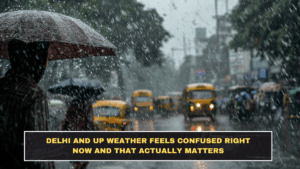
Delhi and nearby Uttar Pradesh are in an unstable weather stretch where warm conditions are colliding with fresh storm activity. The immediate signal is not extreme rain, but a messy pattern of cloud cover, light rain, thunderstorms, and gusty winds. Delhi is under a yellow alert, and IMD’s Delhi forecast says very light to light rain is likely with thunderstorms, lightning, and winds of 30–40 kmph gusting to 50 kmph in parts of the day.
This matters because the weather is not behaving in one clean direction. Delhi saw a warm, sunny day even while the rain alert continued, which is exactly why people misread the risk. A warm afternoon does not cancel a storm warning. It usually means the atmosphere is unstable enough to flip later.
What the Current Alert Actually Means
For Delhi, the IMD bulletin says:
- very light to light rain is likely
- thunderstorms and lightning are possible
- surface winds may reach 30–40 kmph, gusting to 50 kmph
- another spell of drizzle or light rain may return later in the day or evening
For Uttar Pradesh, current reporting says places such as Noida and Lucknow are expected to stay cloudy with chances of light rain, and temperatures may fall by up to 5°C in some areas as the weather shifts. Wider IMD-linked reporting also says western and central UP are among the zones likely to see rain and gusty winds.
The Simple Breakdown Readers Need
| Issue | Latest detail | Why it matters |
|---|---|---|
| Delhi alert level | Yellow alert for rain and gusty winds | Means weather disruption is possible, not guaranteed all-day rain. |
| Delhi wind risk | 30–40 kmph, gusting to 50 kmph | Can affect two-wheelers, traffic flow, and exposed outdoor movement. |
| Delhi rain pattern | Very light to light rain / drizzle with thunderstorm risk | Suggests stop-start disruption rather than a continuous wet day. |
| UP temperature effect | Up to 5°C drop reported in parts of the state | Explains why the weather feels unstable rather than steadily hot. |
| Wider regional pattern | Delhi and UP are among several northern states under storm-rain influence | Shows this is part of a broader western-disturbance pattern, not an isolated city event. |
Why This Matters More Than People Think
The problem is not that Delhi or UP are facing some historic storm. The problem is the instability. People usually plan badly in this kind of weather because they expect a clean forecast: either hot or rainy. Right now it is neither. Delhi can stay warm, then turn windy and wet later. UP can look cloudy and harmless, then cool quickly with passing rain and gusty conditions. That kind of shift matters for office commutes, school pickups, road travel, and any outdoor plans built on lazy assumptions.
The wider IMD-linked pattern also shows this is being driven by active western disturbances across north India. That is why Delhi, UP, Punjab, Uttarakhand and nearby zones are all seeing linked weather swings instead of isolated local showers.
What Commuters and Travellers Should Actually Watch
Use a basic filter instead of guessing:
- Watch the wind, not just the rain. Gusty winds can create more disruption than light showers.
- Assume delays are possible in evening travel windows. IMD’s Delhi bulletin points to repeated spells, not one fixed event.
- Do not judge the whole day by the morning sky. Delhi already showed that a warm day can still sit under a rain alert.
- For UP, expect local variation. Noida and Lucknow may both see cloud and light-rain conditions, but the exact disruption level can differ by district.
Conclusion
Delhi and UP weather feels confused right now because it is. The current setup is a mix of warmth, cloud, light rain, thunderstorms, and gusty winds tied to a wider north India disturbance pattern. The useful takeaway is not to overreact, but to stop pretending a yellow alert is meaningless. In this kind of weather, short bursts of wind and rain can matter more than the total rainfall number.
FAQs
Is Delhi under a weather alert right now?
Yes. Delhi is under a yellow alert for rain and gusty winds, with IMD forecasting very light to light rain, thunderstorms, lightning, and winds gusting up to 50 kmph.
What is happening in Uttar Pradesh weather today?
Reporting says cities such as Noida and Lucknow are expected to stay cloudy with chances of light rain, and temperatures could drop by around 5°C in some areas.
Will this bring a proper cool-down?
Possibly only briefly. Current reporting suggests a temporary drop in temperatures, but the broader pattern is unstable rather than a full seasonal shift.
Why does this weather matter for daily life?
Because the main disruption risk comes from quick changes: gusty winds, stop-start rain, and thunderstorm windows that can affect commutes and outdoor plans even without heavy all-day rain.